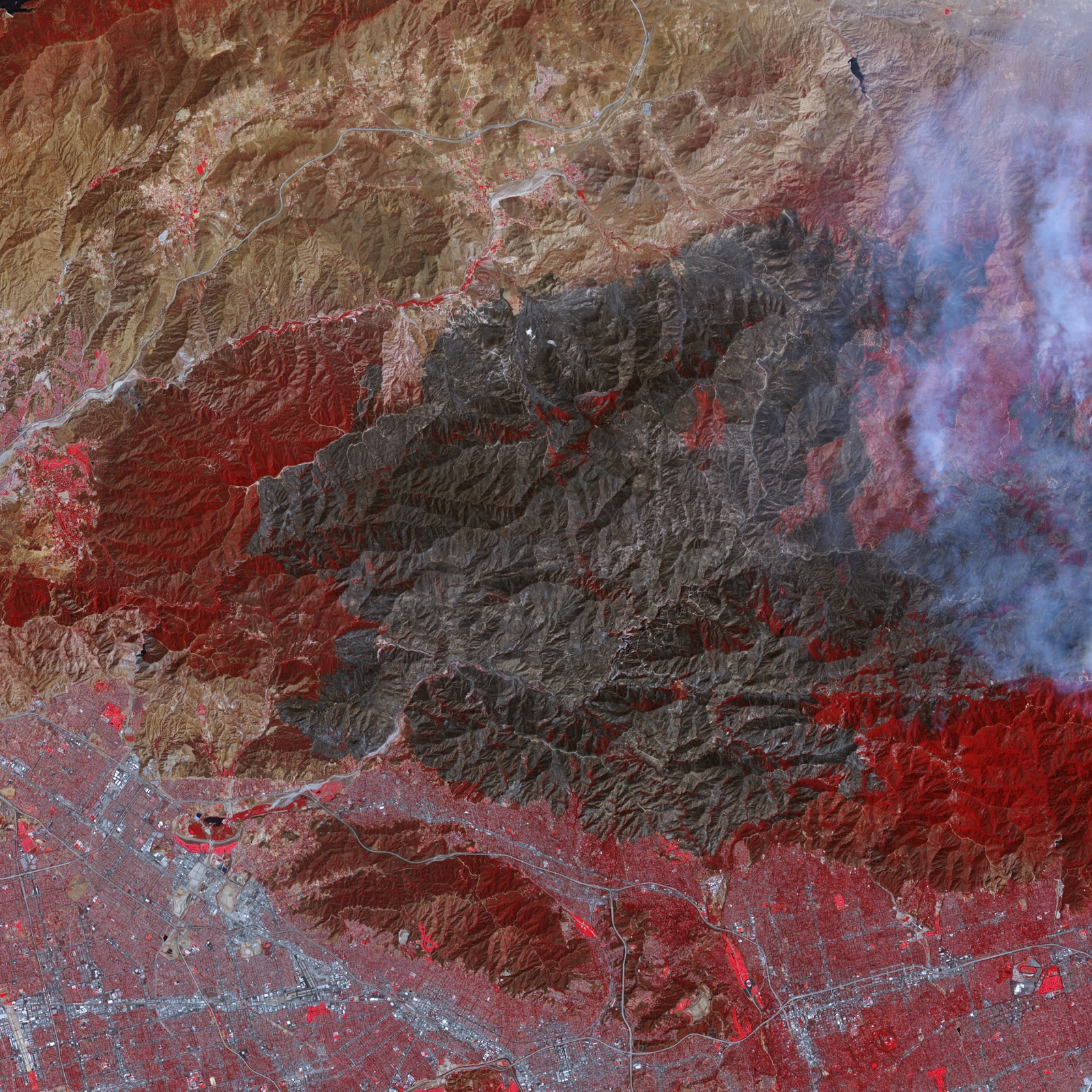

This report is on the effects of the
Station fire of Southern California during 2009. I created a GIS using ArcMap
that includes the areas that the fire burned with a cities layer, a major
highways layer, and an airports layer. Another map is included that depicts a
satellite image taken by NASA that shows the aftermath of the fires. This
report will focus on how the fire affected the layers I included in the GIS and
the overall impact of the fire.
The Station fire began on August 26,
2009 and burned close to 160,577 acres of land in in the Los Angeles County.
Eighty-nine structures were destroyed and two firemen lost their lives to
contain this fire. It burned through the end of September and was completely
contained on October 16th, 2009. Evacuation orders for the cities
and communities in the surrounding areas of the fire. These orders even
included animals from the Wildlife Waystation in Little Tujunga Canyon. Among these
evacuated animals were tigers, lions, bears, chimpanzees, mountain lions, and
others housed in the waystation.
Homes
and other structures only included part of the destruction that the Station fire
unleashed. The Angeles Crest Highway, a commonly used Los Angeles Highway, was
closed until 2011 because the condition of the asphalt and guardrails were too
unsafe to be driven on. This highway starts north of downtown and runs for
sixty-six miles to the community of Wrightwood. This is just an example of the
strength of the fire. Another closure that was caused by the fire was the
Angeles National Forest. The fire burned away tens of thousands of acres in the
park and had to be closed until the conditions of the park could be improved.
Although
I included an airport layer in the GIS, I could not locate information on how
the fire affected airports. The massive amounts of smoke in the air that the
fire created could have obscured the Southern California skies. After mapping
the locations of the airports, the distance between the area that was burned by
the fire and the airports is too great for smoke to affect air traffic.
GIS
has helped me take a look at the Station fire of 2009 that reading news
articles about the topic would not have provided. GIS programs such as ArcMap
are completely necessary for tasks such as mapping out the areas burned by a
fire and layering on features that were impacted.
Works Cited
Allen, Carolyn. “Perspective on SoCal
Wildfires – Station Fire, 2009.” California
Green
Solutions. Web. <http://www.californiagreensolutions.com/cgi-
bin/gt/tpl.h,content=3241P>
Solutions. Web. <http://www.californiagreensolutions.com/cgi-
bin/gt/tpl.h,content=3241P>
Allen, Jesse. “Fires in Los Angeles
County.” Earth Observatory NASA. Web.
8
September 2011. <http://earthobservatory.nasa.gov/IOTD/view.php?id=40118>
September 2011. <http://earthobservatory.nasa.gov/IOTD/view.php?id=40118>
“Angeles Highway Scheduled to Reopen Friday.”
CBS Los Angeles. Web. 2 June 2011.
<http://losangeles.cbslocal.com/2011/06/02/angeles-crest-highway-scheduled-to-
reopen-friday/>
reopen-friday/>
Bloomekatz, Ari B. “Station fire was
arson, officials say; homicide investigations begin.”
Los Angeles Times. Web. 3 September 2009.
<http://latimesblogs.latimes.com/lanow/2009/09/station-fire-was-arson-homicide-
investigation-begins.html>
<http://latimesblogs.latimes.com/lanow/2009/09/station-fire-was-arson-homicide-
investigation-begins.html>
Lieberman, Jonny. “Another Station Fire
bummer: Angeles Crest Highway closed
indefinitely.” AutoBlog. Web. 7 September 2009.
<http://www.autoblog.com/2009/09/07/another-station-fire-bummer-angeles-
crest-highway-closed-indefi/>
indefinitely.” AutoBlog. Web. 7 September 2009.
<http://www.autoblog.com/2009/09/07/another-station-fire-bummer-angeles-
crest-highway-closed-indefi/>
“Wildfires in Southern California.” Boston.com. Web. 2 September 2009.
<http://www.boston.com/bigpicture/2009/09/wildfires_in_southern
<http://www.boston.com/bigpicture/2009/09/wildfires_in_southern
_californ.html>
No comments:
Post a Comment